Home / Landscapes / Taï - Grebo-Krahn - Sapo / Taï - Grebo-Krahn - Sapo protected areas / Taï National Park
Taï National Park
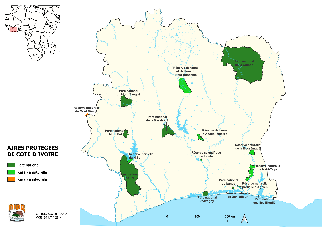
Location
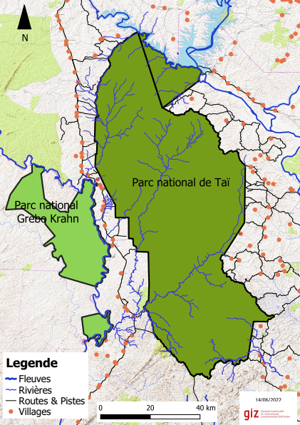
The Taï National Park (PNT) and the adjoining N’Zo Partial Natural Fauna Reserve (RPFN) were created in 1972 on the basis of a decision taken as early as 1926 to protect an immense area of dense evergreen rainforest in the south-west of Côte d’Ivoire between the Sassandra and Cavally rivers.
The massif is shared between the Nawa, San-Pedro and Cavally regions. Managed by the Office Ivoirien des Parcs et Réserves (OIPR) through its South-West Zone Directorate (Direction de Zone Sud-Ouest (DZSO)) as a single area under the name of Taï National Park (TNP), the two units TNP and (RPFN) cover an area of 536.016 ha.
Taï NP covers 25 % of the total surface area of Côte d’Ivoire’s network of 17 protected areas.
Biodiversity
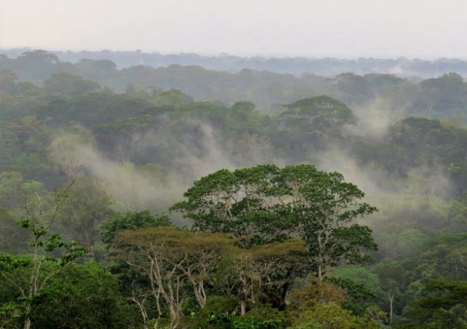
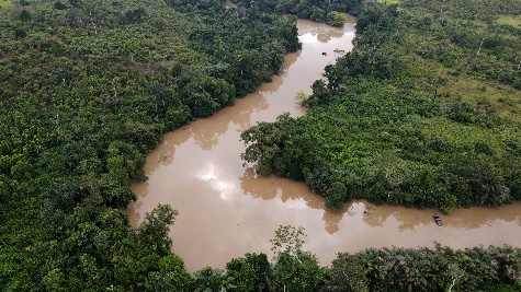
Taï National Park is the largest area of dense rainforest in West Africa under strict protection. Over 98.4 % of its surface area is occupied by natural forest cover, most of which is characterised by various types of evergreen forest growth, shaped by annual rainfall in excess of 1 600 mm.
The remaining 1.6 % is largely occupied by the waters of Lake Buyo and the denuded slopes of Mount Niénokoué.
TNP’s plant heritage is unique, with over 1 200 species, with 273 classified as rare or endemic (Van Rompaey et al., 2001). Of these species, 73 are of great interest (Adou Yao et al, 2002) for forest conservation, hence the importance of TNP as a reservoir of unique biodiversity in the West African sub-region. This flora is comparable to that of Grebo-Krahn and Sapo national parks further west in Liberia, which contributes to the uniqueness of the Taï - Grebo-Krahn - Sapo landscape.
Sassandrian endemism is essentially in terms of species, with the exception of a few genera: Triphyophyllum, with a single, locally abundant liana species of the Dioncophyllaceae family; Monosalpinx (Rubiaceae), the only known species in Côte d’Ivoire; Polystemonanthus (Caesalpiniaceae) and Kantou (Sapotaceae), with the unique and rare Inhambarella guereensis species, the sacred tree of the Guéré people.
The park contains 42% of the plant species classified in Côte d’Ivoire as "rare and/or threatened" on the IUCN Red List (2016).
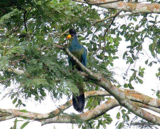
The particularity of TNP is also reflected in its fauna. It contains over 90 % of West Africa’s forest fauna, including 146 mammal species (forest elephant, pygmy hippopotamus, leopard, forest buffalo, giant forest hog, giant pangolin, tailed monkeys, chimpanzees, etc.), 234 bird species, 15 of global interest, including the white-breasted guineafowl, rufous fishing owl, white-necked rockfowl, etc, 56 amphibian species, 42 reptile species and almost 300 insect species. 65 species of fish have been recorded in the rivers that flow through the park.
The Great blue turaco (Corythaeola cristata) is a species of cultural interest to the Patokola people in the south-west of the park.
As with the flora, some fauna species (and subspecies in the case of primates) are rare and/or endemic to West Africa, such as Jentink’s duiker (Cephalophus jentinki), found strictly west of Sassandra, the zebra duiker (Cephalophus zebra) and the Western chimpanzee (Pan troglodytes verus).
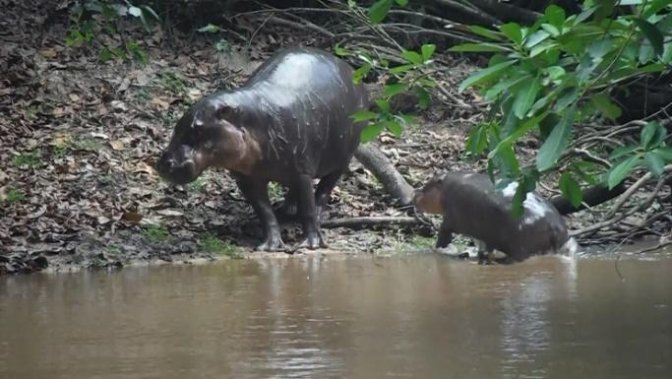
Also endemic to West Africa and "vulnerable" according to the IUCN (among almost 43 species mentioned on the 2016 Red List), the largest population in the world of the pygmy hippopotamus (Choeropsis liberiensis) is in the TNP.
As a result of this exceptional richness, TNP has enjoyed Biosphere Reserve status since 1978, and was added to UNESCO’s list of World Heritage Sites in 1982. This international recognition give it the status of a globally important forest.
Pressure and threats
Illegal gold panning is practised in the west of the TNP along the Hana river. Outside the park, it is carried out to both the east and west in the rivers and shallows of the rural areas and classified forests. These illegal activities destroy soils and habitats, and pollute watercourses.
After gold panning, which is localised, poaching is the other major pressure on the protected area, and affects the entire park. It is carried out with snare traps and 12-gauge shotguns. Duiker and monkeys are the main species hunted.
As for illegal fishing, some fishermen on Lake Buyo use nets with mesh that is too fine, and do not respect protected spawning areas. As a result, fish stocks are dwindling and certain riparian species (otters, turtles and reptiles, water birds, etc.) are becoming increasingly rare.
Despite the strong pressure on rural land on the periphery of the park, land clearing for agricultural purposes has been contained by strong action in the past and constant surveillance in the field. Nonetheless, this is a major threat, which requires us to remain vigilant.
In terms of indirect ecological threats, the first is the island effect of the TNP due to a very high level of agricultural occupation (over 95 %) of the land on its entire periphery, including in the classified forests belonging to the Taï area, which isolates flora and fauna populations and carries the risk of genetic impoverishment for these species in the long term.
In addition to the pollution of watercourses by products used in gold panning, pollution is also caused by agricultural inputs (pesticides and chemical fertilisers) used indiscriminately around the TNP. This concerns the upstream basins of the Hana and N’zè rivers to the north-east and north-west respectively, as well as the banks of Lake Buyo in the N’Zo Fauna Reserve to the north. The negative consequences for aquatic fauna and their predators (as well as for the health of the communities that use this resource on the periphery) are inevitable.
Finally, climate change is a threat that has yet to be fully assessed, with changes to be expected in terms of the frequency and intensity of rainfall episodes and in terms of difficulties for the fruiting and regeneration of certain plant species.
Management
Since 1997, TNP has had a development and management plan (PAG), which is periodically revised in a participatory manner by the OIPR and management stakeholders, for 10-year periods. The latest validated PAG runs from 2020 to 2029. Annual planning and budgeting is provided for the implementation of this document.
A Local Management Committee (LMC) ensures that stakeholders take part in the park’s management. This committee is made up of representatives of the administrative authorities, local authorities, local communities, the private sector and research and higher education centres, as well as technical and financial partners involved in the management of the TNP.
Typically, development and management plans are organised around 6 programmes: (i) surveillance, (ii) ecological monitoring and research, (iii) support for local development or "neighbourhood measures", (iv) outreach (communication and education to raise awareness of conservation values and ecosystem services, and promote ecotourism), (v) infrastructure and equipment, (vi) management. In the last PAG, programme (vi) was strengthened by the concept of cross-border collaboration for consultative management of the Taï - Grebo-Krahn - Sapo landscape.
Current management is achieving the expected results, particularly in terms of responses to direct pressures and threats to TNP, as shown by the assessments made by UNESCO for the Biosphere Reserves and World Heritage Sites, and in the use of the IMET (Integrated Management Effectiveness Tool), METT (Management Effectiveness Tracking Tool) and EoH (Enhancing our Heritage) tools to periodically measure the effectiveness of park management and make recommendations.
In light of these results and in its ongoing vision to improve the governance of its protected areas, through the OIPR, Côte d’Ivoire has been engaged since 2017 in the IUCN "Green List" process of protected and conserved areas, certifying a protected area for its good management demonstrated by convincing and sustainable results in terms of nature conservation and benefits for humans. The TNP application for the Green List was submitted to the IUCN expert group in 2023 for analysis.
German development cooperation contributions to TGKS projects
German development cooperation has been supporting the Ivorian government for almost 40 years in the sustainable management of the TNP (capacity building, surveillance, ecological monitoring, research, local development, etc.), and in 2009 joined a cross-border collaborative effort initiated by the governments of Liberia and Côte d’Ivoire with their partners in the Taï –Grebo-Krahn – Sapo landscape for the conservation of its exceptional biodiversity.
Two new projects were launched, starting in late 2015 and early 2017 respectively:
- The project "Strengthening ecological connectivity in the Taï-Grebo-Sapo forest complex between Côte d’Ivoire and Liberia", implemented by GiZ, and
- The project "Biodiversity conservation in the Taï-Grebo-Sapo complex", funded by KfW and implemented by the AHT-CSRS consortium.
The main implementing partners are Côte d’Ivoire’s MINEDD (Ministry of the Environment and Sustainable Development) and OIPR, and in Liberia, the FDA (Forestry Development Authority). In 2019, the European Union proposed that GiZ reinforce its TGS project with co-financing under PAPFor. This action started in July 2020.
The basic idea behind these 2 projects is to foster connectivity between the 3 protected areas in the TGS landscape, including the Grebo-Krahn National Park, which was created on the basis of the "Grebo National Forest" in 2017 (with support from the TGS-GiZ project), to reinforce its former conservation status. Responding to the concern about the island effect of protected areas already mentioned for the TNP, "ecological connectivity" is a complex process that must enable the exchange of populations of fauna (above all) and flora, either through continuous wooded corridors, or through a discontinuous network of wooded areas. All projects take into account the good management of connected protected areas and the active involvement of local communities.
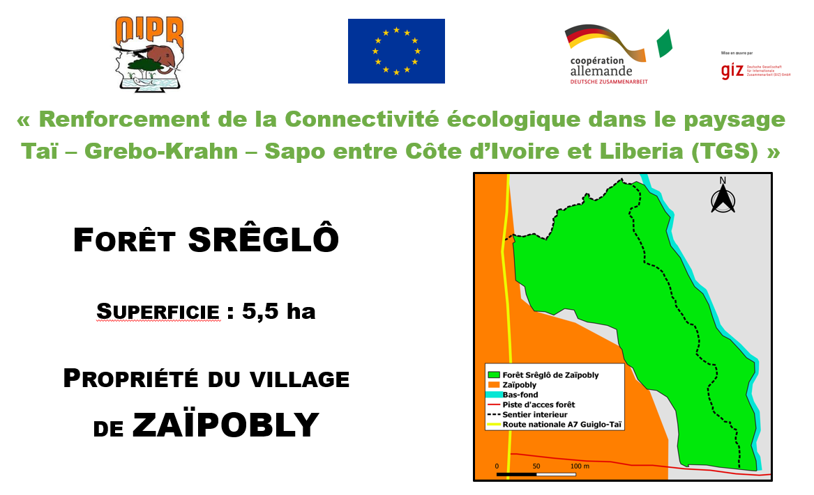
In the western part of the Taï area, between the TNP and the Cavally river, the TGS-GiZ project is working on support for the sustainable management of residual forests (18 village forests and the banks of the Hana, Méno and Moumo rivers) and the promotion of agroforestry systems designed to maintain or return trees to a deforested rural landscape. To revegetate the banks of the Hana river, the TGS project is working in partnership with Beyond-Beans, a foundation of the Export Trading Group (ETG), a multinational trader and processor of agricultural products (including cocoa), which supports good farming practices through training and input kits supplied each year as payments for environmental services for releasing part of their plantation to natural regeneration and adopting agroforestry practices.
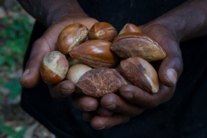
For agroforestry, TGS relies on the existing presence of nursery cultivation in the Taï department of a forest species, the Makoré – Tieghemella heckelii, from whose fruit butter for food and cosmetic use can be extracted.
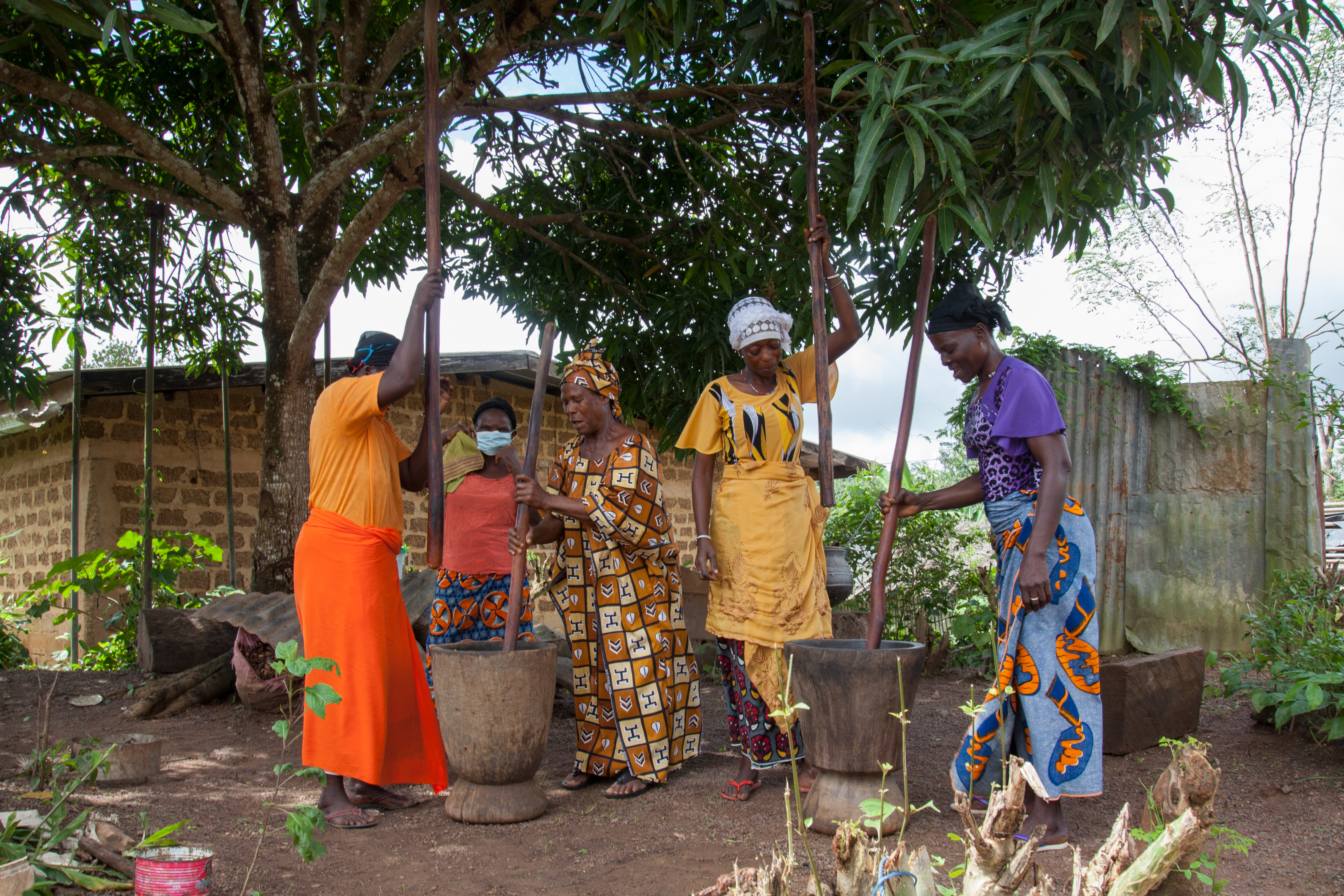
One side effect of increasing connectivity for conservation is the development of value chains for non-timber forest products (NTFPs), which can help boost the economic prospects for local communities. A group of 55 women from Zaïpobly, the Tanties Troti, receives support for the development of makoré butter production and a second nursery activity (potential of 5 million seedlings produced per year, sold to companies and cooperatives in the cocoa sector).
In addition, and in the spirit of "periphery measures" introduced by OIPR to develop the TNP, support has been provided to 6 villages for the participative preparation of local development plans, and is being actively pursued with capacity-building to support the implementation of these plans, particularly for activities chosen by volunteers such as grasscutter (Greater cane rat) farming, snail farming, fish farming, rice farming, beekeeping, etc.
Lastly, while the TGS-GiZ project is directly involved in promoting a green network in village territories and local development in the west of the Taï area, this area is also involved in the TGS-MINEDD-KfW project, the Ivorian component of the "Conservation of biodiversity in the TGS" project.
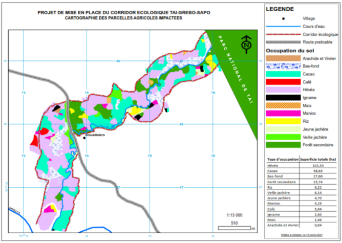
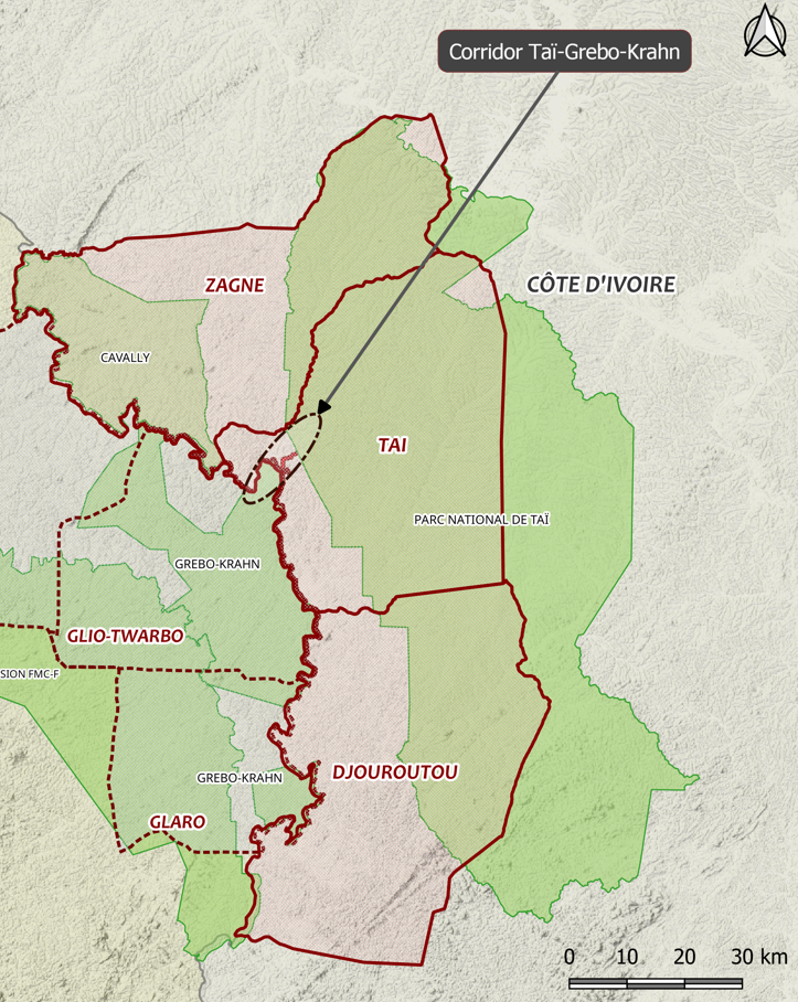
Following a 2-year feasibility study (2017-2019), a project concept for the development of a woodland corridor has been approved along the Saro river, 3 kilometres south-east of the town of Taï, at the narrowest point between TNP and the Cavally river (4 linear km along the river). At 450 m wide, the proposed corridor covers 236 ha.
The choice of target wildlife species (species under whose ecological requirements a number of species will find their way along the corridor) to develop the corridor was based on the following:
- 3 primary species: Forest elephant, Pygmy hippopotamus, Diana monkey
- 4 secondary species: Dwarf crocodile, Jentink’s duiker, Chimpanzee, White-breasted guinea fowl.
Negotiations with the communities affected (3 villages and 1 settlement), and more specifically the people affected by the project (PAP), were carried out to assess compensation for the change in use of their land and to jointly define the boundaries of the future corridor. Once the PAP had reached agreement and been compensated in March-April 2023, the Project Implementation Unit (PIU) is free to undertake measures to secure the corridor and curb encroachment, pending its creation as a Voluntary Nature Reserve at the request of the Management Committee, set up by the communities in April 2022.
A detailed plant inventory has already identified 235 species on the site that are eaten by large fauna (elephants, monkeys including chimpanzees, duikers and pygmy hippopotamuses), which is an asset. Discussions are underway on possible human-wildlife conflicts, the demarcation of boundaries, forest restoration in the corridor and the development of agroforestry on neighbouring land.